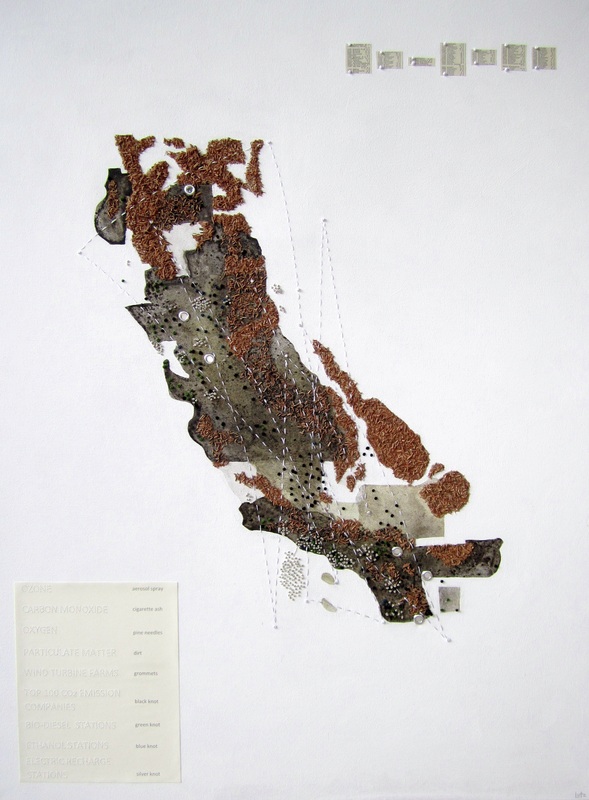
 About the workAs with everything in life, there are challenges and solutions. This could not ring more true than in dealing with not only an artistic collaboration, but with the well-being and health of everyone, as it pertains to representing the planning of… AIR…?! It seemed so unbelievably overwhelming. Not only is it the largest portion of our landscape, it is the one environmental element that we absolutely must have to live. We need to breathe, period. What we breathe, what causes us harm to breathe, what needs to be done to create clean air and who is responsible for this was the point of departure for the project.
We chose to focus on California as a basic framework because that relates to the initial project at hand with the Inland Empire Planning Association. At first it seemed like a good idea to outline the various Air Quality Regulation regions and Counties. Early into my research I found it peculiar that there are outlines to compartmentalize the accountability for the SKY above a particular location. I could only imagine how difficult this must get when the Santa Ana’s kick in every summer. Accountability and action requires effort beyond any one organization’s regulations, any one corporation’s emission standard accountability, and any one individual’s effort to recycle, ride a bike, or even quit smoking. Here lies the conundrum that planners face: keeping everyone happy while implementing accountability for…air. It still seemed beyond our grasp, literally and metaphorically. After about 3 more weeks’ worth of researching maps and reading about natural aspects and man-made impact, it seemed important for me to portray the nebulous nature of air quality in general. This felt natural to me, since my work already revolves around the landscape and conceptually translating the sky. I also work with maps or conceptual mapping. For this project the repetition of sewing and the time spent gathering smog or plant material was an effective way to portray the care that needs to be taken regarding sustainability and fragility of air quality. In addition, the materials create a tactile response for the viewer and a way to make something invisible and ungraspable, into something noticeable and tangible. A map is a strong educational tool – it defines the landscape, helps us get somewhere, tells us where we have been. It tells a story within its information and helps us make decisions – whether tracking a small journey across the state, or a prompt to plant more trees or a reminder to use recyclable products. This poses the question, what will a map like this show us in 10 years, and what would a new map look like? History will be our guide, but now is the time to rethink our understanding of sustainability, and to take action to make a difference for the future. I hope the map I created prompts people to think about environmental issues and how we could create new habits. – Leora Lutz |
 |